WEKO3
アイテム
ERUPTION ID:18-0208
http://hdl.handle.net/10232/0002001713
http://hdl.handle.net/10232/0002001713be99b640-d02d-4062-8ae4-4a881c935e41
| アイテムタイプ | VASH(1) | |||||||||
|---|---|---|---|---|---|---|---|---|---|---|
| 公開日 | 2025-11-13 | |||||||||
| タイトル | ||||||||||
| タイトル | ERUPTION ID:18-0208 | |||||||||
| 言語 | ja | |||||||||
| 作成者 |
京都大学防災研究所
× 京都大学防災研究所
× 鹿児島大学水産学部
|
|||||||||
| アクセス権 | ||||||||||
| アクセス権 | open access | |||||||||
| 内容記述 | ||||||||||
| 内容記述 | 桜島火山降灰量分布データベース(Database of Sakurajima Volcanic ASH-fall Distributions : VASH) | |||||||||
| 出版者 | ||||||||||
| 出版者 | 京都大学防災研究所 | |||||||||
| 噴火日(地方標準時) | ||||||||||
| 噴火日(地方標準時) | 2018-05-25 | |||||||||
| 噴火時刻(地方標準時) | ||||||||||
| 噴火時刻(地方標準時) | 13:26 | |||||||||
| 噴煙高度(m) | ||||||||||
| 噴煙高度(m) | 3000 | |||||||||
| 総降灰量(kg) | ||||||||||
| 総降灰量(kg) | 5.11E+04 | |||||||||
| 降灰総面積(km2) | ||||||||||
| 降灰総面積(km2) | 2.23 | |||||||||
| 検索キーワード(統制語) | ||||||||||
| 検索キーワード(統制語) | 南岳 | |||||||||
| 検索キーワード(統制語) | ||||||||||
| 検索キーワード(統制語) | 噴石 | |||||||||
| 噴火年 | ||||||||||
| 噴火年 | 2018 | |||||||||
| 噴煙高度(統制語) | ||||||||||
| 噴煙高度(統制語) | 3000―4000m | |||||||||
| 言語 | ||||||||||
| 言語 | jpn | |||||||||
| 資源タイプ | ||||||||||
| 資源タイプ | dataset | |||||||||
| ファイル説明(Basic information) | ||||||||||
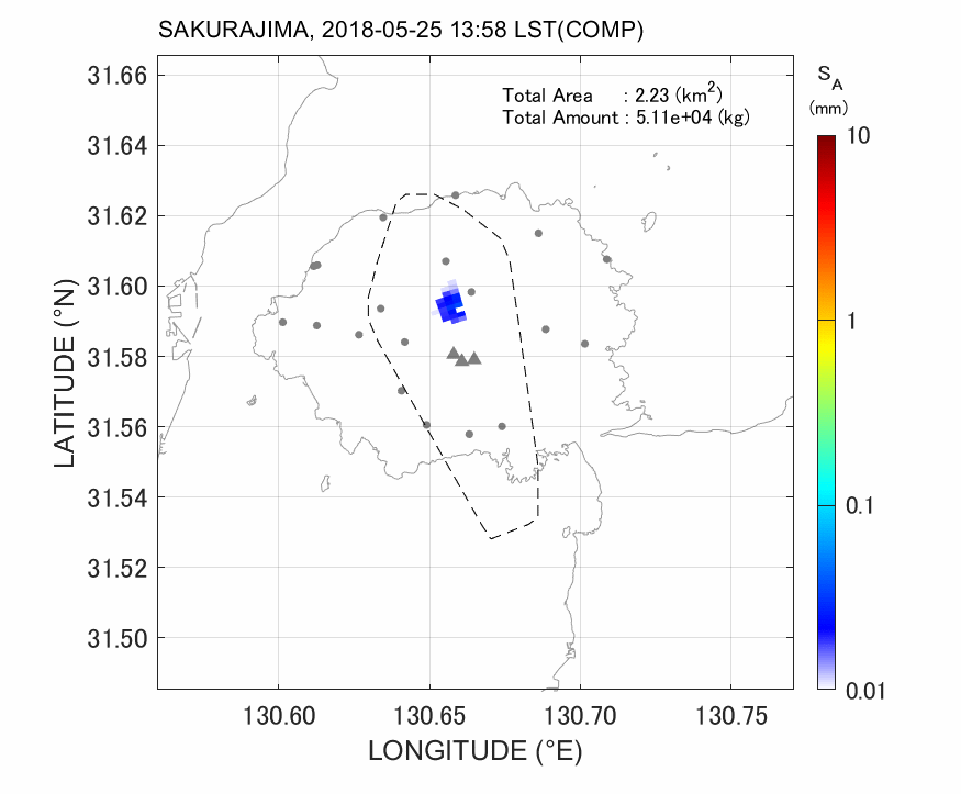
| 説明 | skr18-0208_xmp_mlit-01.png | |||||||||
| ファイル説明(Basic information) | ||||||||||
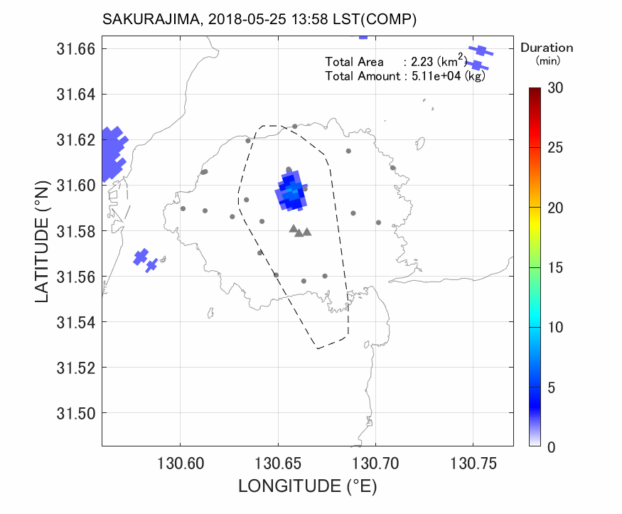
| 説明 | skr18-0208_xmp_mlit-02.png | |||||||||
| ファイル説明(Specific information: PHOTO) | ||||||||||
| 説明 | skr18-0208_photo-01.mp4 : Fig. 1-1 Photo from Tarumizu, Kagoshima (courtesy of Dr.Iino, Kumamoto Univ.). | |||||||||
| ファイル説明(Specific information: PHOTO) | ||||||||||
| 説明 | skr18-0208_photo-02.mp4 : Fig. 1-2 Photo from Kinkodai, Kagoshima (courtesy of Dr. Iino, Kumamoto Univ.). | |||||||||
| ファイル説明(Specific information: MLIT_XMP) | ||||||||||
| 説明 | skr18-0208_xmp_mlit-01.mp4 : Fig. 2-1 Accumulated ash fall distribution (animation). | |||||||||
| ファイル説明(Specific information: MLIT_XMP) | ||||||||||
| 説明 | skr18-0208_xmp_mlit-02.mp4 : Fig. 2-2 Ash fall duration time (animation). | |||||||||
| ファイル説明(Specific information: MLIT_XMP) | ||||||||||
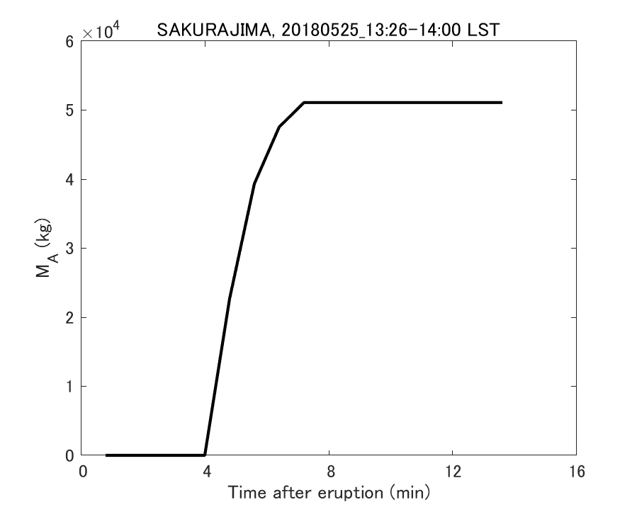
| 説明 | skr18-0208_xmp_mlit-03.png : Fig. 2-3 Temporal change of total ash fall amount. | |||||||||
| ファイル説明(Specific information: MLIT_XMP) | ||||||||||
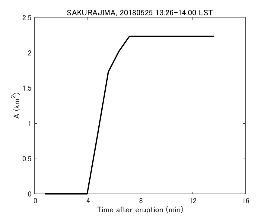
| 説明 | skr18-0208_xmp_mlit-04.png : Fig. 2-4 Temporal change of total ash fall area. | |||||||||
| ファイル説明(Specific information: SVO_XMP) | ||||||||||
| 説明 | skr18-0208_xmp_svo-01.mp4 : Fig. 4-3 RHI images of radar reflectivity factor ZH (animation). | |||||||||
| ファイル説明(Specific information: SVO_XMP) | ||||||||||
| 説明 | skr18-0208_xmp_svo-02.mp4 : Fig. 4-4 RHI images of Doppler velocity VD(animation). | |||||||||
| ファイル説明(Specific information: SVO_XMP) | ||||||||||
| 説明 | skr18-0208_xmp_svo-03.mp4 : Fig. 4-5 RHI images of differential reflectivity ZDR (animation). | |||||||||
| ファイル説明(Specific information: SVO_XMP) | ||||||||||
| 説明 | skr18-0208_xmp_svo-04.mp4 : Fig. 4-6 RHI images of specific differential phase KDP(animation). | |||||||||
| ファイル説明(Specific information: MARIE RADAR) | ||||||||||
| 説明 | skr18-0208_marine-01.mp4 : Fig. 5-1 Development of eruption column. | |||||||||
| ファイル説明(Specific information: Meteorological Information) | ||||||||||
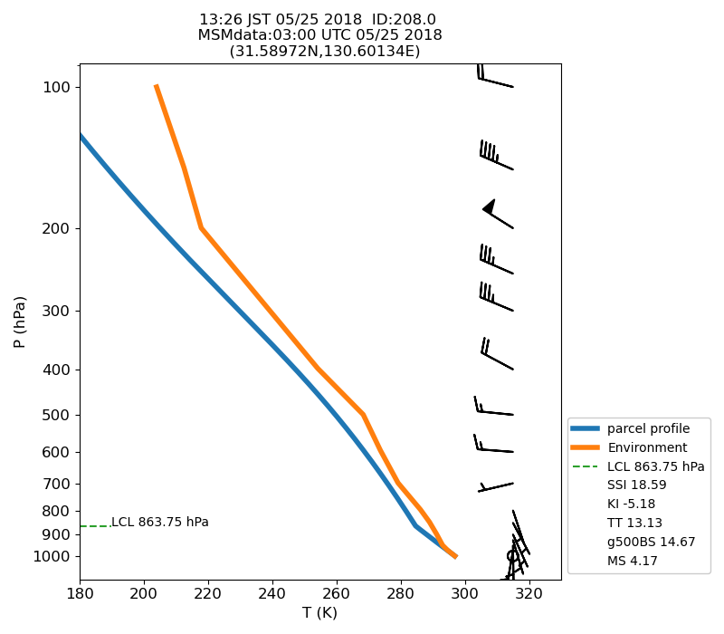
| 説明 | skr18-0208_msm-01.png : Fig. 7-1 Atmospheric instability in the upper atmosphere shown by the emagram. | |||||||||
| * | ||||||||||
| ** | ||||||||||
